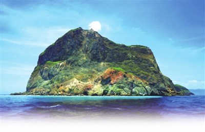
 龜山島南側沿海火山岩壁,因受海水侵蝕,形成狀似眼鏡的鐘乳石洞,洞內石柱及石筍保存完整,是島上著名的八大奇景之一。
圖/林格立
龜山島南側沿海火山岩壁,因受海水侵蝕,形成狀似眼鏡的鐘乳石洞,洞內石柱及石筍保存完整,是島上著名的八大奇景之一。
圖/林格立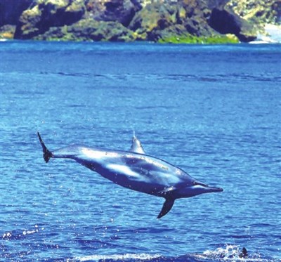 登島賞景之外,乘船賞鯨、繞島一窺火山全貌,也是旅遊龜山島的熱門行程。
圖/林格立
登島賞景之外,乘船賞鯨、繞島一窺火山全貌,也是旅遊龜山島的熱門行程。
圖/林格立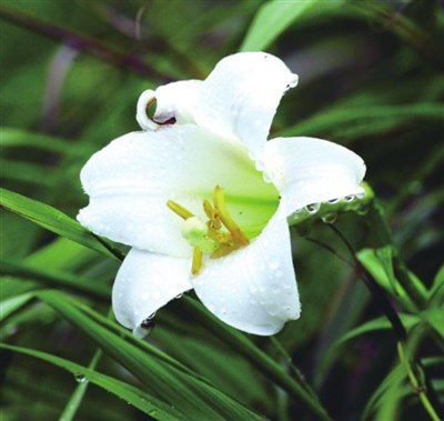 龜山島龜尾部分適合遊憩,春天登島可見盛開的台灣百合。
圖/林格立
龜山島龜尾部分適合遊憩,春天登島可見盛開的台灣百合。
圖/林格立
提要
二○一三年農委會林務局舉辦「台灣十大地景」選拔,龜山島獲第五名,僅次於野柳、玉山主峰、日月潭及金瓜石。龜山島勝出的關鍵,不在其龜狀外觀,而在於它是十大地景之中唯一的活火山,在學者專家眼中,其科學研究及地質現象的價值,不輸前四大地景。
Guishan Island lies in coastal waters 12 kilometers northeast of Yilan. The island is 2.8 square kilometers in area, and from certain angles it resembles a sea turtle floating on the ocean, with its head facing eastward into the Pacific and its tail pointing toward Taiwan.
Guishan Island, considered a spiritual symbol by the people of Yilan, was a military zone for 23 years. It was opened to tourism in 2000, but due to restrictions on visitor numbers, people regard it, like its volcanic past, as shrouded in layers of mystery.
There are two volcanic vents on Guishan Island: one at the head of the turtle and one at the shell. A survey by an NTU Geosciences Department research team suggests that the volcano at the turtle’s shell has erupted at least four times in the past 7,000 years, but the most recent eruption may have occurred at the turtle’s head.
The turtle’s shell is the main section of Guishan Island, with the highest point being 401 Peak at the middle of the southern end of the shell. The volcanic vent may be located there.
The turtle’s head, located on the eastern end of Guishan Island, is shaped like an elliptic cone. Its topography is high in the east and low in the west, and its coastline is steep. The volcano at the turtle’s head is believed to be younger than the volcano on the turtle’s shell. Fumaroles have been found on the sea floor by the turtle’s head, spewing hot sulfurous gases and forming marine hot springs. The gases bubbling to the surface appear as a roiling white foam that can be seen year round. This seabed hot spring is one of Guishan Island’s “eight wonders.”
There are also fumaroles on the cliff, constantly emitting sulfurous fumes, another of the “eight wonders.”
Volcanic rock is a remnant of eruptions. In addition to andesitic volcanic debris, heaps of volcanic ash of different grain sizes can be seen in the area from the turtle’s head to its neck.
In 2000, Guishan Island was officially incorporated within the Tourism Bureau’s Northeast Coast National Scenic Area, and it was opened to a limited number of tourists a day. But somewhat disappointingly, the level areas most suited to recreation are clustered at the turtle’s tail, which takes up just one tenth of the island’s area.
Liu Shih-ming, deputy director of the Northeast and Yilan Coast National Scenic Area Administration, says that people walking on the loop trail around Guiwei Lake, located at the turtle’s tail, can see artillery emplacements and tunnels left behind after the military base was closed, as well as houses and historical objects of island residents from an earlier time.
In addition, coastal vegetation such as butterfruit and screwpine grows here in abundance, and in the springtime you can see lilies blooming. It takes about an hour and a half to explore the turtle’s tail.
The turtle’s tail itself is a spur of gravel beach that juts about a kilometer into the sea. It moves north and south with seasonal winds and currents, creating the legendary “wagging turtle tail.” The closer you get to the turtle shell, the more clearly you can see the volcanic vistas of lava hills and volcanic rocks.
According to the scenic area administration, there have been around 110,000 visits to the island per year in the last three years. To see the more inaccessible turtle head and shell, you need to take a boat trip around the island.
翻譯
龜山島座落在宜蘭東北方十二公里的海面上,全島面積二點八平方公里,外形像一隻浮出水面的海龜,龜首朝東望向太平洋,龜尾擺向台灣。
被宜蘭人視為精神象徵的龜山島,曾有長達二十三年的時間被畫為軍事用地。二○○○年起開放民眾登島觀光,但因有人數名額限制,因此外界看它,就跟它的火山身世一樣,蓋著好幾層面紗。
龜山島上有二個火山口,分別在龜首與龜甲。台大地質系研究團隊調查後,推斷七千年來,龜甲火山至少噴發了四次,全島迄今最後一次噴發可能發生在龜首上。
龜甲部分是龜山島的主體,最高峰約四百零一公尺,座落在龜甲南緣的中央,有「四○一高地」的稱號。龜甲上的火山口,可能就是位在這裡。
龜首呈橢圓錐狀,位在龜山島的東方,地勢東高西低,沿岸地勢陡峭。龜首火山被認為比龜甲火山年輕。龜首火山在海底找到出氣孔,噴出硫磺熱氣形成海底溫泉,湧出海面後,終年可見白色泡沫翻滾,此即龜山島八景之一的「海底溫泉湧上流」。
此外,岩壁上也有硫氣噴孔,不斷冒出硫磺煙氣,所形成的「龜島磺煙」也是八景之一。
火山岩是火山噴發的遺跡,龜首除了可見安山岩質的火山碎屑岩,在龜首至龜頸處,也可見顆粒大小不一的火山灰落堆積物。
二○○○年龜山島正式被畫入交通部觀光局東北角海岸國家風景特定區,每日開放限額民眾登島觀光,龜山島才慢慢揭開面紗。
但較可惜的是,全島適合遊憩、賞景的平地區域,集中在龜尾,面積僅占全島的十分之一。
東北角暨宜蘭海岸國家風景區管理處副處長劉士銘表示,沿著龜尾島上的「龜尾湖」建有環湖步道,民眾沿著步道走,可看到軍方撤退後,保留下來的砲台與坑道設施,以及更早之前島上住民的住屋與歷史文物。
此外,龜尾遍植毛柿、林投樹等海濱植物,春天可見百合花盛開。遊憩龜尾一周,約需一點五小時。
地形上,龜尾臨海部分由長約一公里的礫石灘沙嘴構成;沙嘴的延伸方向,隨冬、夏季風和海流變化而南、北位移,形成傳說中的「靈龜擺尾」景象。龜尾越往龜甲靠近,熔岩丘、火山岩等火山島的景觀就越明顯。
東北角風管處統計,近三年來,每年約有十一萬人次登島。足跡難以去達的龜首、龜甲,民眾須搭船繞島才能窺其樣貌。
文/朱立群
(摘錄轉載自《台灣光華雜誌》四月號全文請參考http://www.taiwan-panorama.com/)
對話
A: Let's stop and look at the souvenirs at the souvenir stand.
B: What types of souvenirs were you looking for?
A: When I travel, I usually like to bring back a special necklace or clothing for my family.
B: What types of things do they like?
A: The little kids like little trinkets, like those little shell animals over there.
B: I feel like this stuff is kind of overpriced.
A: Some souvenir stands charge more than others, so it pays to shop around.
B: Why don